Virtual Walk - The Works of [email protected] - Don Stockton
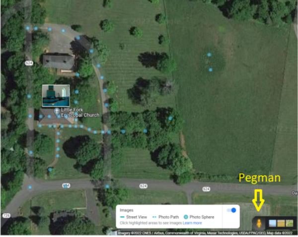
Since May of this year we have been working on a way to reach out to more people and let them know what kind of a gem we have here at Little Fork. After purchasing a new scanner to record every page of the 1731 Saint Mark’s Parish record and the many documents recording the progress since I decided there needed to be a better way to make it available and started by taking pictures of all the memorial plates and plaques in the church with a smart phone, attaching them to Google Maps associated with Little Fork then found out we could use the Google Street View Application to create a Photo Path or Photo Sphere.
The Photo Sphere resulted the first 360 degree photograph standing in front of the church. Then discovering the GoPro Camera decided it was time to let the world see the inside of our Gem resulting in what is published today on www.google.com/maps. Just click the link and click once on the little yellow Pegman in the bottom right corner to turn on the photo points as shown in the map image. After that you can either just click on one of the points or drag the Pegman to where you want to start. From there arrows and X’s will be displayed where you can navigate, including inside the church.
We hope over time to add more thru the years as we implement our Master Plan but for now we would like to make each point of interest within the church and the Burying Ground a hot spot linked to all the stones, plates and plaques for those searching their past. Google keeps track of each view of every picture published and since May when first started up to this writing there have been over 18,000 views, the biggest hitter so far has been looking at the church from the walkway with almost 1000 views. The latest addition are the two points on top of what may be a native burial mound in the East field (more research has begun).
Tags: News & Events / History
